Difference between revisions of "Jefferson Township, Somerset County, Pennsylvania"
m |
m |
||
| Line 15: | Line 15: | ||
|mapsize1 = 250x200px | |mapsize1 = 250x200px | ||
|map_caption1 = Map of Somerset County, Pennsylvania | |map_caption1 = Map of Somerset County, Pennsylvania | ||
| − | + | ||
|subdivision_type = [[wikipedia:List of countries|Country]] | |subdivision_type = [[wikipedia:List of countries|Country]] | ||
|subdivision_name = [[wikipedia:United States|United States]] | |subdivision_name = [[wikipedia:United States|United States]] | ||
| Line 58: | Line 58: | ||
|footnotes = | |footnotes = | ||
}} | }} | ||
| + | |||
Revision as of 16:47, 13 April 2014
| Jefferson Township, Somerset County, Pennsylvania | |
|---|---|
| Township | |
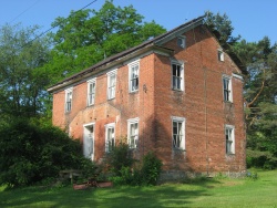
 The abandoned William P. Hay House on Jimtown Road | |
 Map of Somerset County, Pennsylvania Highlighting Jefferson Township | |
 Map of Somerset County, Pennsylvania | |
| Country | United States |
| State | Pennsylvania |
| County | Somerset |
| Area | |
| • Total | 41.5 sq mi (107 km2) |
| • Land | 41.3 sq mi (107 km2) |
| • Water | 0.2 sq mi (0.5 km2) |
| Population (2000) | |
| • Total | 1,375 |
| • Density | 33.3/sq mi (12.9/km2) |
| Time zone | Eastern (EST) (UTC-5) |
| • Summer (DST) | EDT (UTC-4) |