Difference between revisions of "LaRue County, Kentucky"
m |
m |
||
| Line 1: | Line 1: | ||
{{Infobox U.S. county | {{Infobox U.S. county | ||
| − | | county = LaRue County | + | | county = LaRue County |
| − | | state = Kentucky | + | | state = Kentucky |
| − | | seal = | + | | seal = |
| − | | founded | + | | founded = 4 March 1843 (created) |
| − | + | | seat wl = Hodgenville | |
| − | | seat wl = Hodgenville | + | | largest city = Hodgenville |
| − | | largest city | + | | area_total_sq_mi = 264 |
| − | | area_total_sq_mi = 264 | + | | area_land_sq_mi = 262 |
| − | | area_land_sq_mi = 262 | + | | area_water_sq_mi = 2.1 |
| − | | area_water_sq_mi = 2.1 | + | | area percentage = 0.8% |
| − | | area percentage = 0.8% | ||
| census estimate yr = 2018 | | census estimate yr = 2018 | ||
| − | | pop = 14307 | + | | pop = 14307 |
| − | | time zone = Eastern | + | | time zone = [[wikipedia:Eastern Time Zone|Eastern]] |
| − | | ex image = Larue County Kentucky courthouse.jpg | + | | ex image = Larue County Kentucky courthouse.jpg |
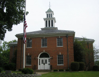
| − | | ex image cap = LaRue County courthouse in Hodgenville | + | | ex image cap = LaRue County courthouse in Hodgenville |
| footnotes = For infobox source see<ref>{{cite web | | footnotes = For infobox source see<ref>{{cite web | ||
| title = LaRue County, Kentucky | | title = LaRue County, Kentucky | ||
| publisher = Wikipedia | | publisher = Wikipedia | ||
| url = https://en.wikipedia.org/wiki/LaRue_County,_Kentucky | | url = https://en.wikipedia.org/wiki/LaRue_County,_Kentucky | ||
| − | | accessdate = 2020- | + | | accessdate = 2020-11-04}}</ref> |
}}__TOC__ | }}__TOC__ | ||
== County Well Data == | == County Well Data == | ||
Latest revision as of 19:34, 4 November 2020
| LaRue County, Kentucky | |
|---|---|
|
LaRue County courthouse in Hodgenville | |
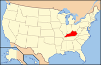
 Location in the state of Kentucky | |
 Kentucky's location in the U.S. | |
| Founded | 4 March 1843 (created) |
| Seat | Hodgenville |
| Largest city | Hodgenville |
| Area | |
| • Total | 264 sq mi (684 km2) |
| • Land | 262 sq mi (679 km2) |
| • Water | 2.1 sq mi (5 km2), 0.8% |
| Population (Est.) | |
| • (2018) | 14,307 |
| Time zone | Easternwikipedia:Category:Infobox U.S. county using a non-standard timezone |
| Footnotes: For infobox source see[1] | |
Contents
County Well Data
| Well ID | Operator Name | Well Type | Well Status |
|---|---|---|---|
| 16-123-00009 | OIL & NATURAL GAS WELL | WELL DEVELOPMENT | |
| 16-123-00020 | OIL & NATURAL GAS WELL | STORAGE WELL/MAINTENANCE WELL/OBSERVATION WELL | |
| 16-123-00028 | OIL & NATURAL GAS WELL | UNKNOWN WELL | |
| 16-123-00071 | OIL & NATURAL GAS WELL | UNKNOWN WELL | |
| 16-123-00072 | OIL & NATURAL GAS WELL | UNKNOWN WELL | |
| 16-123-00074 | OIL & NATURAL GAS WELL | UNKNOWN WELL |
For data sources see[2]
References
- ↑ "LaRue County, Kentucky". Wikipedia. Retrieved 2020-11-04.
- ↑ "Oil and Natural Gas Wells". Homeland Infrastructure Foundation-Level Data. 2019-09-24. Retrieved 2020-09-12.
