Difference between revisions of "Bandera County, Texas"
m |
m |
||
| (One intermediate revision by the same user not shown) | |||
| Line 1: | Line 1: | ||
| − | {{Infobox U.S. | + | {{Infobox U.S. county| |
county = Bandera County| | county = Bandera County| | ||
state = Texas | | state = Texas | | ||
| − | seal =| | + | flag = https://www.crwflags.com/FOTW/images/u/us-tx-ba.gif | |
| + | seal = Bandera County, Texas seal.gif | | ||
founded year = 1856| | founded year = 1856| | ||
seat wl = Bandera | | seat wl = Bandera | | ||
| − | largest city wl = Lakehills| | + | largest city wl = Lakehills | |
| − | city type = community| | + | city type = community | |
| − | area_total_sq_mi =798 | | + | area_total_sq_mi = 798 | |
| − | area_land_sq_mi = | + | area_land_sq_mi = 791 | |
| − | area_water_sq_mi =6 | | + | area_water_sq_mi = 6.7 | |
| − | area percentage = 0. | + | area percentage = 0.8% | |
census yr = 2010 | | census yr = 2010 | | ||
pop = 20485 | | pop = 20485 | | ||
| − | + | density_sq_mi = 26 | | |
| − | web = www.banderacounty.org| | + | web = https://www.banderacounty.org/ | |
| − | ex image = Bandera county courthouse.jpg| | + | ex image = Bandera county courthouse.jpg | |
| − | ex image size = 250| | + | ex image size = 250 | |
| − | ex image cap =The Bandera County Courthouse in Bandera. The building was added to the National Register of Historic Places on October 31, 1979. | + | ex image cap = The Bandera County Courthouse in Bandera. The building was added to the National Register of Historic Places on October 31, 1979. |
| − | | | + | | time zone = Central |
| − | | | + | | named for = [[wikipedia:Bandera Pass|Bandera Pass]] |
| − | __TOC__ | + | | footnotes = For infobox source see<ref>{{cite web |
| − | == | + | | title = Bandera County, Texas |
| + | | publisher = Wikipedia | ||
| + | | url = https://en.wikipedia.org/wiki/Bandera_County,_Texas | ||
| + | | accessdate = 2020-12-09}}</ref> | ||
| + | }}__TOC__ | ||
| + | == County Well Data == | ||
{| class="wikitable sortable" width="95%" | {| class="wikitable sortable" width="95%" | ||
!scope="col" | Well ID | !scope="col" | Well ID | ||
| − | |||
!scope="col" | Operator Name | !scope="col" | Operator Name | ||
| − | !scope="col" | | + | !scope="col" | Well Type |
| − | !scope="col" | | + | !scope="col" | Lease |
| − | + | |- | |
| − | + | | [[42-019-30192]] | |
| − | + | | [[MRT EXPLORATION COMPANY]] | |
| − | + | | | |
| + | | | ||
| + | |- | ||
| + | | [[42-019-30193]] | ||
| + | | [[Damson Oil Corp.]] | ||
| + | | | ||
| + | | | ||
| + | |- | ||
| + | | [[42-019-30194]] | ||
| + | | [[MRT EXPLORATION COMPANY]] | ||
| + | | | ||
| + | | | ||
| + | |- | ||
| + | | [[42-019-30195]] | ||
| + | | [[Damson Oil Corp.]] | ||
| + | | | ||
| + | | | ||
| + | |- | ||
| + | | [[42-019-30196]] | ||
| + | | [[CHAPMAN OIL]] | ||
| + | | | ||
| + | | | ||
| + | |- | ||
| + | | [[42-019-30197]] | ||
| + | | [[Conoco Inc.]] | ||
| + | | | ||
| + | | | ||
| + | |- | ||
| + | | [[42-019-30198]] | ||
| + | | [[Conoco Inc.]] | ||
| + | | | ||
| + | | | ||
| + | |- | ||
| + | | [[42-019-30199]] | ||
| + | | [[STOKES, KING]] | ||
| + | | | ||
| + | | | ||
| + | |- | ||
| + | | [[42-019-30200]] | ||
| + | | [[STOKES, KING]] | ||
| + | | | ||
| + | | | ||
| + | |- | ||
| + | | [[42-019-30201]] | ||
| + | | [[CHAPMAN OIL]] | ||
| + | | | ||
| + | | | ||
| + | |- | ||
| + | | [[42-019-30202]] | ||
| + | | [[WALTERS, R. E.]] | ||
| + | | | ||
| + | | | ||
| + | |- | ||
| + | | [[42-019-30203]] | ||
| + | | [[SCANTECH EXPLORATION, INC.]] | ||
| + | | | ||
| + | | | ||
| + | |- | ||
| + | | [[42-019-30204]] | ||
| + | | [[WALTERS, R. E.]] | ||
| + | | | ||
| + | | | ||
| + | |- | ||
| + | | [[42-019-30205]] | ||
| + | | [[BUSCAR OIL COMPANY]] | ||
| + | | | ||
| + | | | ||
| + | |- | ||
| + | | [[42-019-30206]] | ||
| + | | | ||
| + | | | ||
| + | | | ||
| + | |- | ||
| + | | [[42-019-30207]] | ||
| + | | [[LEGACY ENERGY SERVICES]] | ||
| + | | Oil | ||
| + | | 13973 | ||
| + | |- | ||
| + | | [[42-019-30208]] | ||
| + | | | ||
| + | | | ||
| + | | | ||
| + | |- | ||
| + | | [[42-019-30209]] | ||
| + | | [[LEGACY ENERGY SERVICES]] | ||
| + | | Oil | ||
| + | | 13973 | ||
| + | |- | ||
| + | | [[42-019-30210]] | ||
| + | | [[DEVON SFS OPERATING, INC.]] | ||
| + | | Oil | ||
| + | | 14372 | ||
| + | |- | ||
| + | | [[42-019-30211]] | ||
| + | | [[DEVON SFS OPERATING, INC.]] | ||
| + | | | ||
| + | | | ||
| + | |- | ||
| + | | [[42-019-30212]] | ||
| + | | [[DEVON SFS OPERATING, INC.]] | ||
| + | | | ||
| + | | | ||
| + | |- | ||
| + | | [[42-019-30213]] | ||
| + | | [[GULFSTAR PROPERTIES, INC.]] | ||
| + | | Oil | ||
| + | | 15085 | ||
| + | |- | ||
| + | | [[42-019-30214]] | ||
| + | | [[TEPEE PETROLEUM CO., INC.]] | ||
| + | | | ||
| + | | | ||
| + | |- | ||
| + | | [[42-019-30215]] | ||
| + | | [[FOUNDATION ENERGY MANAGEMENT LLC]] | ||
| + | | Oil | ||
| + | | 15005 | ||
| + | |- | ||
| + | | [[42-019-30216]] | ||
| + | | [[PATTERSON ENERGY CORPORATION]] | ||
| + | | Gas | ||
| + | | 253768 | ||
| + | |- | ||
| + | | [[42-019-30217]] | ||
| + | | [[GULFSTAR PROPERTIES, INC.]] | ||
| + | | | ||
| + | | | ||
| + | |- | ||
| + | | [[42-019-30218]] | ||
| + | | [[SOUTH GULF ENTERPRISES, INC.]] | ||
| + | | | ||
| + | | | ||
| + | |- | ||
| + | | [[42-019-80000]] | ||
| + | | [[STOKES, KING]] | ||
| + | | | ||
| + | | | ||
| + | |- | ||
|} | |} | ||
| + | For data sources see<ref>{{cite web | ||
| + | | title = RRC Digital Map Data | ||
| + | |publisher = Railrod Commission of Texas | ||
| + | | date = 2020-10-15 | ||
| + | | url = https://wellwiki.org/wiki/Texas_Oil_and_Gas_Data_Sources | ||
| + | | accessdate = 2020-10-15 }}</ref> | ||
| + | ==References== | ||
| + | <references/> | ||
__NOEDITSECTION__ | __NOEDITSECTION__ | ||
| − | |||
Latest revision as of 16:59, 9 December 2020
| Bandera County, Texas | |||
|---|---|---|---|
|
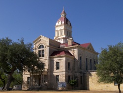
The Bandera County Courthouse in Bandera. The building was added to the National Register of Historic Places on October 31, 1979. | |||
| |||
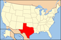
 Location in the state of Texas | |||
 Texas's location in the U.S. | |||
| Founded | 1856 | ||
| Named for | Bandera Pass | ||
| Seat | Bandera | ||
| Largest community | Lakehills | ||
| Area | |||
| • Total | 798 sq mi (2,067 km2) | ||
| • Land | 791 sq mi (2,049 km2) | ||
| • Water | 6.7 sq mi (17 km2), 0.8% | ||
| Population | |||
| • (2010) | 20,485 | ||
| • Density | 26/sq mi (10/km²) | ||
| Time zone | Central: UTC-6/-5 | ||
| Website | www.banderacounty.org | ||
| Footnotes: For infobox source see[1] | |||
Contents
County Well Data
For data sources see[2]
References
- ↑ "Bandera County, Texas". Wikipedia. Retrieved 2020-12-09.
- ↑ "RRC Digital Map Data". Railrod Commission of Texas. 2020-10-15. Retrieved 2020-10-15.
