Difference between revisions of "Cherry Tree Borough, Indiana County, Pennsylvania"
m |
m |
||
| Line 8: | Line 8: | ||
|image_skyline = Cherry Tree, Pennsylvania.JPG | |image_skyline = Cherry Tree, Pennsylvania.JPG | ||
|imagesize = | |imagesize = | ||
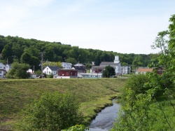
| − | |image_caption = Cherry Tree taken along [[wikipedia:Cush Cushion Creek | + | |image_caption = Cherry Tree taken along [[wikipedia:Cush Cushion Creek|Cush Cushion Creek]] and the flood control levee. |
|image_flag = | |image_flag = | ||
|flag_size = | |flag_size = | ||
| Line 24: | Line 24: | ||
|coordinates_region = US-PA | |coordinates_region = US-PA | ||
|subdivision_type = [[wikipedia:List of countries|Country]] | |subdivision_type = [[wikipedia:List of countries|Country]] | ||
| − | |subdivision_name = [[wikipedia:United States | + | |subdivision_name = [[wikipedia:United States|United States]] |
|subdivision_type1 = [[wikipedia:Political divisions of the United States|State]] | |subdivision_type1 = [[wikipedia:Political divisions of the United States|State]] | ||
| − | |subdivision_name1 = [[wikipedia:Pennsylvania | + | |subdivision_name1 = [[wikipedia:Pennsylvania|Pennsylvania]] |
|subdivision_type2 = [[wikipedia:List of counties in Pennsylvania|County]] | |subdivision_type2 = [[wikipedia:List of counties in Pennsylvania|County]] | ||
|subdivision_name2 = [[wikipedia:Indiana County, Pennsylvania|Indiana]] | |subdivision_name2 = [[wikipedia:Indiana County, Pennsylvania|Indiana]] | ||
| Line 79: | Line 79: | ||
|elevation_m = | |elevation_m = | ||
|elevation_ft = | |elevation_ft = | ||
| − | |postal_code_type = [[wikipedia:Zip code | + | |postal_code_type = [[wikipedia:Zip code|Zip code]] |
| − | |||
| − | |||
| − | |||
| − | |||
| − | |||
| − | |||
| − | |||
| − | |||
| − | |||
| − | |||
| − | |||
| − | |||
| − | |||
| − | |||
| − | |||
| − | |||
| − | |||
| − | |||
| − | |||
| − | |||
| − | |||
| − | |||
| − | |||
| − | |||
| − | |||
| − | |||
| − | |||
| − | |||
| − | |||
| − | |||
| − | |||
| − | |||
| − | |||
| − | |||
| − | |||
| − | |||
| − | |||
| − | |||
| − | |||
| − | |||
| − | |||
| − | |||
| − | |||
| − | |||
| − | |||
| − | |||
| − | |||
| − | |||
| − | |||
| − | |||
| − | |||
| − | |||
| − | |||
| − | |||
| − | |||
| − | |||
| − | |||
| − | |||
| − | |||
| − | |||
| − | |||
| − | |||
| − | |||
| − | |||
| − | |||
| − | |||
| − | |||
| − | |||
| − | |||
| − | |||
| − | |||
| − | |||
| − | |||
| − | |||
| − | |||
| − | |||
| − | |||
| − | |||
| − | |||
| − | |||
| − | |||
| − | |||
| − | |||
| − | |||
| − | |||
| − | |||
|postal_code = 15724 | |postal_code = 15724 | ||
|area_code = | |area_code = | ||
| Line 171: | Line 85: | ||
|footnotes = | |footnotes = | ||
}} | }} | ||
| + | |||
| + | |||
== Municipality Details == | == Municipality Details == | ||
__TOC__ | __TOC__ | ||
Revision as of 18:06, 11 April 2014
| Cherry Tree, Pennsylvania | |
|---|---|
| Borough | |
 Cherry Tree taken along Cush Cushion Creek and the flood control levee. | |
|
| |
|
Coordinates: 40°43′35″N 78°48′27″W / 40.72639°N 78.80750°WCoordinates: 40°43′35″N 78°48′27″W / 40.72639°N 78.80750°W Fatal error: The format of the coordinate could not be determined. Parsing failed. | |
| Country | United States |
| State | Pennsylvania |
| County | Indiana |
| Government | |
| • Type | Borough Council |
| Area | |
| • Total | 0.5 sq mi (1 km2) |
| Population (2010) | |
| • Total | 364 |
| • Density | 833.4/sq mi (321.8/km2) |
| Time zone | Eastern (EST) (UTC-5) |
| • Summer (DST) | EDT (UTC-4) |
| Zip code | 15724 |
