|
|
| Line 75: |
Line 75: |
| | | website = http://www.chalfont.govoffice.com | | | website = http://www.chalfont.govoffice.com |
| | }} | | }} |
| − | {{Geobox
| + | |
| − | | Settlement
| + | |
| − | <!-- *** Name section *** -->
| |
| − | | name = Borough of Chalfont
| |
| − | | native_name =
| |
| − | | other_name =
| |
| − | | other_name1 =
| |
| − | | category = [[wikipedia:home rule municipality (Pennsylvania)|home rule municipality]]
| |
| − | <!-- *** Image *** -->
| |
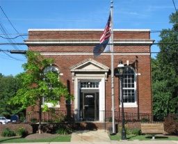
| − | | image = Chalfont.jpg
| |
| − | | image_size =
| |
| − | | image_caption = Borough building
| |
| − | <!-- *** Symbols *** -->
| |
| − | | flag =
| |
| − | | flag_size =
| |
| − | | symbol_type = Seal
| |
| − | | symbol = SealofChalfontPA.jpg
| |
| − | | symbol_size =
| |
| − | <!-- *** Nickname & motto *** -->
| |
| − | | nickname =
| |
| − | | motto =
| |
| − | <!-- *** Country etc. *** -->
| |
| − | | country = United States
| |
| − | | state = Pennsylvania
| |
| − | | region = [[wikipedia:Bucks County, Pennsylvania|Bucks]]
| |
| − | | region_type = County
| |
| − | | district =
| |
| − | <!-- *** Geography *** -->
| |
| − | | area_imperial = 1.6
| |
| − | | area_land_imperial = 1.6
| |
| − | | area_water_imperial = 0.0
| |
| − | | area_water_percentage = auto
| |
| − | | area_percentage_round = 2
| |
| − | | area_round = 1
| |
| − | | lat_d = 40
| |
| − | | lat_m = 17
| |
| − | | lat_s = 23
| |
| − | | lat_NS = N
| |
| − | | long_d = 75
| |
| − | | long_m = 12
| |
| − | | long_s = 37
| |
| − | | long_EW = W
| |
| − | | elevation_imperial = 272
| |
| − | | elevation_round = 1
| |
| − | <!-- *** Population *** -->
| |
| − | | population_as_of = 2010
| |
| − | | population = 4,009
| |
| − | | population_density_imperial = 2365.8
| |
| − | | population_density_round = 1
| |
| − | <!-- *** Government *** -->
| |
| − | | government_type =
| |
| − | | government =
| |
| − | | established_type =
| |
| − | | established =
| |
| − | | mayor = Marilyn J. Becker
| |
| − | <!-- *** Various codes *** -->
| |
| − | | timezone = [[wikipedia:North American Eastern Time Zone|EST]]
| |
| − | | utc_offset = -5
| |
| − | | timezone_DST = [[wikipedia:Eastern Daylight Time|EDT]]
| |
| − | | utc_offset_DST = -4
| |
| − | | postal_code =
| |
| − | | postal_code_type =
| |
| − | | area_code = [[wikipedia:Area code 215|215]]
| |
| − | | area_code_type =
| |
| − | | code2_type =
| |
| − | | code2 =
| |
| − | <!-- *** Free fields *** -->
| |
| − | | free_type =
| |
| − | | free =
| |
| − | | free1_type =
| |
| − | | free1 =
| |
| − | <!-- *** Map section *** -->
| |
| − | | map = Bucks county - Chalfont.png
| |
| − | | map_size =
| |
| − | | map_caption = Location of Chalfont in Bucks County
| |
| − | | map1 = Pennsylvania Locator Map.PNG
| |
| − | | map1_size =
| |
| − | | map1_caption = Location of Chalfont in Pennsylvania
| |
| − | | map1_locator = Pennsylvania
| |
| − | | map2 = Map of USA PA.svg
| |
| − | | map2_caption = Location of Pennsylvania in the United States
| |
| − | <!-- *** Website *** -->
| |
| − | | website = http://www.chalfont.govoffice.com
| |
| − | }}
| |
| | | | |
| | | | |


