Difference between revisions of "Mountville Borough, Lancaster County, Pennsylvania"
m |
m |
||
| Line 1: | Line 1: | ||
{{Geobox | {{Geobox | ||
| Settlement | | Settlement | ||
| − | + | ||
| name = Borough of Mountville | | name = Borough of Mountville | ||
| native_name = | | native_name = | ||
| Line 7: | Line 7: | ||
| other_name1 = | | other_name1 = | ||
| category = | | category = | ||
| − | + | ||
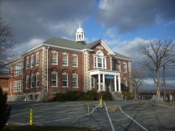
| image = Mountville Community Center.jpg | | image = Mountville Community Center.jpg | ||
| image_size = | | image_size = | ||
| image_caption = Mountville Community Center | | image_caption = Mountville Community Center | ||
| − | + | ||
| flag = | | flag = | ||
| flag_size = | | flag_size = | ||
| symbol = | | symbol = | ||
| symbol_size = | | symbol_size = | ||
| − | + | ||
| country = United States | | country = United States | ||
| state = Pennsylvania | | state = Pennsylvania | ||
| Line 22: | Line 22: | ||
| region_type = County | | region_type = County | ||
| district = | | district = | ||
| − | + | ||
| area_imperial = 0.9 | | area_imperial = 0.9 | ||
| area_land_imperial = 0.9 | | area_land_imperial = 0.9 | ||
| Line 32: | Line 32: | ||
| elevation_imperial = 443 | | elevation_imperial = 443 | ||
| elevation_round = 1 | | elevation_round = 1 | ||
| − | + | ||
| population_as_of = 2000 | | population_as_of = 2000 | ||
| population = 2444 | | population = 2444 | ||
| population_density_imperial = 2856.8 | | population_density_imperial = 2856.8 | ||
| population_density_round = 1 | | population_density_round = 1 | ||
| − | + | ||
| established_type = | | established_type = | ||
| established = | | established = | ||
| mayor = | | mayor = | ||
| − | + | ||
| timezone = [[wikipedia:North American Eastern Time Zone|EST]] | | timezone = [[wikipedia:North American Eastern Time Zone|EST]] | ||
| utc_offset = -5 | | utc_offset = -5 | ||
| Line 52: | Line 52: | ||
| code2_type = | | code2_type = | ||
| code2 = | | code2 = | ||
| − | + | ||
| free_type = | | free_type = | ||
| free = | | free = | ||
| free1_type = | | free1_type = | ||
| free1 = | | free1 = | ||
| − | + | ||
| map = Mountville, Lancaster County Highlighted.png | | map = Mountville, Lancaster County Highlighted.png | ||
| map_caption = Location of Mountville in Lancaster County | | map_caption = Location of Mountville in Lancaster County | ||
| Line 65: | Line 65: | ||
| map2 = Map of USA PA.svg | | map2 = Map of USA PA.svg | ||
| map2_caption = Location of Pennsylvania in the United States | | map2_caption = Location of Pennsylvania in the United States | ||
| − | + | ||
| website = | | website = | ||
}} | }} | ||
| + | |||
Revision as of 17:10, 13 April 2014
| Borough of Mountville | |
| Settlement | |
Mountville Community Center
| |
| Country | United States |
|---|---|
| State | Pennsylvania |
| County | Lancaster |
| Elevation | 443 ft (135 m) |
| Area | 0.9 sq mi (2.3 km2) |
| - land | 0.9 sq mi (2 km2) |
| - water | 0.0 sq mi (0 km2), 0% |
| Population | 2,444 (2000) |
| Density | 2,856.8 / sq mi (1,103 / km2) |
| Timezone | EST (UTC-5) |
| - summer (DST) | EDT (UTC-4) |
| ZIP Code | 17554 |
| Area code | 717 |


