Difference between revisions of "St. Thomas, Elgin, Ontario"
m |
m |
||
| Line 5: | Line 5: | ||
|other_name = | |other_name = | ||
|native_name = | |native_name = | ||
| − | |||
|flag_size = | |flag_size = | ||
|seal_size = | |seal_size = | ||
| − | | | + | | pushpin_label = |
| − | |||
| − | |||
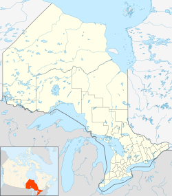
| image_map = {{Location map | Ontario municipal districts | | image_map = {{Location map | Ontario municipal districts | ||
| width = 250 | | width = 250 | ||
| Line 16: | Line 13: | ||
| lon_deg = 81 | lon_min = 11 | lon_sec = 0 | lon_dir = W | | lon_deg = 81 | lon_min = 11 | lon_sec = 0 | lon_dir = W | ||
| label = St. Thomas}} | | label = St. Thomas}} | ||
| + | |subdivision_type = [[wikipedia:Countries of the world|Country]] | ||
| + | |subdivision_name = Canada | ||
|subdivision_type1 = [[wikipedia:Provinces and territories of Canada|Province]] | |subdivision_type1 = [[wikipedia:Provinces and territories of Canada|Province]] | ||
|subdivision_name1 = [[wikipedia:Ontario|Ontario]] | |subdivision_name1 = [[wikipedia:Ontario|Ontario]] | ||
| Line 52: | Line 51: | ||
|postal_code = [[wikipedia:List of N postal codes of Canada|N5P to N5R]] | |postal_code = [[wikipedia:List of N postal codes of Canada|N5P to N5R]] | ||
|area_code = [[wikipedia:Area codes 519 and 226|519 and 226]] | |area_code = [[wikipedia:Area codes 519 and 226|519 and 226]] | ||
| − | |||
|website = http://www.stthomas.ca/ | |website = http://www.stthomas.ca/ | ||
| footnotes = For infobox source see<ref>{{cite web | | footnotes = For infobox source see<ref>{{cite web | ||
| Line 58: | Line 56: | ||
| publisher = Wikipedia | | publisher = Wikipedia | ||
| url = https://en.wikipedia.org/wiki/St._Thomas,_Ontario | | url = https://en.wikipedia.org/wiki/St._Thomas,_Ontario | ||
| − | | accessdate = 2020-08- | + | | accessdate = 2020-08-26}}</ref> |
}}__TOC__ | }}__TOC__ | ||
== Subdivision Well Data == | == Subdivision Well Data == | ||
Revision as of 17:02, 26 August 2020
| St. Thomas | |
|---|---|
| City (single-tier) | |
| City of St. Thomas | |
| Country | Canada |
| Province | Ontario |
| County | Elgin |
| Settled | 1810 |
| Incorporated | 1852 (Village) |
|
1861 (town) 1881 (city) | |
| Area | |
| • Land | 35.52 km2 (13.71 sq mi) |
| Elevation | 209.10 m (686.02 ft) |
| Population (2016) | |
| • City (single-tier) | 38,909 |
| • Density | 1,067.3/km2 (2,764/sq mi) |
| • Urban | 61,707 |
| Time zone | EST (UTC-5) |
| • Summer (DST) | EDT (UTC-4) |
| Forward sortation area | N5P to N5R |
| Area code(s) | 519 and 226 |
| Website | http://www.stthomas.ca/ |
| For infobox source see[1] | |
Contents
Subdivision Well Data
| Well ID | Operator Name | Spud Date | Well Status |
|---|---|---|---|
| F006508 | Dominion Natural Gas Co. Ltd. | No Well Found | |
| N000016 | 1893-07-01 | No Well Found |
For data sources see[2]
References
- ↑ "St. Thomas, Ontario". Wikipedia. Retrieved 2020-08-26.
- ↑ "OGSR Library - Wells". Oil, Gas & Salt Resources Library. 2019-06-13. Retrieved 2020-08-07.
