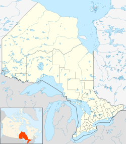
South Dundas, Stormont, Dundas and Glengarry, Ontario
| South Dundas | |
|---|---|
| Municipality (lower-tier) | |
| Municipality of South Dundas | |
| Country | Canada |
| Province | Ontario |
| County | Stormont, Dundas and Glengarry |
| Settled | 1785 |
| Incorporated | 1792 (Royal Townships) |
| Incorporated | 1998 (South Dundas) |
| Area | |
| • Land | 521.06 km2 (201.18 sq mi) |
| Population (2016) | |
| • Total | 10,833 |
| • Density | 20.8/km2 (54/sq mi) |
| Time zone | EST (UTC-5) |
| • Summer (DST) | EDT (UTC-4) |
| Postal code FSA | K0C, K0E |
| Area code(s) | 613 |
| For infobox source see[1] | |
Contents
Subdivision Well Data
| Well ID | Operator Name | Spud Date | Well Status |
|---|---|---|---|
| N000115 | 1954-01-01 | Unknown | |
| N000116 | 1912-01-01 | No Well Found | |
| N000117 | 1913-01-01 | No Well Found | |
| T003707 | Inspiration Drilling | 1973-12-08 | Abandoned Well |
| T003708 | Inspiration Drilling | 1973-11-11 | Abandoned Well |
| T003719 | Inspiration Drilling | 1974-01-07 | Abandoned Well |
| T003721 | Inspiration Drilling | 1973-12-08 | Abandoned Well |
For data sources see[2]
References
- ↑ "South Dundas, Ontario". Wikipedia. Retrieved 2020-09-15.
- ↑ "OGSR Library - Wells". Oil, Gas & Salt Resources Library. 2019-06-13. Retrieved 2020-08-07.
