Meagher County, Montana
| Meagher County, Montana | |
|---|---|
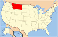
 Location in the state of Montana | |
 Montana's location in the U.S. | |
| Founded | November 16, 1867 |
| Named for | Thomas Francis Meagher |
| Seat | White Sulphur Springs |
| Largest city | White Sulphur Springs |
| Area | |
| • Total | 2,395 sq mi (6,203 km2) |
| • Land | 2,392 sq mi (6,195 km2) |
| • Water | 2.8 sq mi (7 km2), 0.1 |
| Time zone | Mountain: UTC-7/-6 |
| Website | www.meagherco.com |
| Footnotes: For infobox source see[1] | |
Contents
County Well Data
| Well ID | Operator Name | Well Type | Well Status |
|---|---|---|---|
| 25-059-05001 | Drumheller, D.M. | Water | Active |
| 25-059-05002 | PAN AMERICAN PETROLEUM | Water | Dry |
| 25-059-05003 | Tarrant R. C. | Dry Hole | Dry |
| 25-059-05004 | Malone, Ebert | Water | Dry |
| 25-059-21001 | Reunion Energy Company | Dry Hole | Dry |
| 25-059-21002 | Atlantic Richfield Company | Water | Dry |
| 25-059-21003 | Amoco Production Company | Dry Hole | Dry |
| 25-059-21004 | Amoco Production Company | Dry Hole | Dry |
| 25-059-21005 | Fina Oil And Chemical Company | Dry Hole | Dry |
| 25-059-21006 | Amoco Production Company | Dry Hole | Dry |
| 25-059-21007 | Hunt Oil Company | Dry Hole | Dry |
For data sources see[2]
References
- ↑ "Meagher County, Montana". Wikipedia. Retrieved 2020-10-06.
- ↑ "Petroleum related wells". U.S. Geological Survey. 2014-08-06. Retrieved 2020-09-12.
