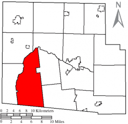
Mcdonald Township, Hardin County, Ohio
| McDonald Township, Hardin County, Ohio | |
|---|---|
| Township | |
 Location of McDonald Township, Hardin County, Ohio | |
| Country | United States |
| State | Ohio |
| County | Hardin |
| Area | |
| • Total | 42.9 sq mi (111.1 km2) |
| • Land | 42.9 sq mi (111.1 km2) |
| • Water | 0.0 sq mi (0.0 km2) |
| Elevation | 1,050 ft (320 m) |
| Population (2010) | |
| • Total | 862 |
| • Density | 20/sq mi (7.8/km2) |
| Time zone | Eastern (EST) (UTC-5) |
| • Summer (DST) | EDT (UTC-4) |
| For infobox source see[1] | |
Contents
Municipality Well Data
| Well ID | Operator Name | Permit Date | Spud Date | Configuration | License Status |
|---|---|---|---|---|---|
| 34-065-20064 | HISTORIC OWNER | Vertical | Plugged and Abandoned | ||
| 34-065-20065 | HISTORIC OWNER | Vertical | Orphan Well - Ready | ||
| 34-065-20070 | HISTORIC OWNER | Vertical | Plugged and Abandoned | ||
| 34-065-20073 | HISTORIC OWNER | 1960-12-02 | 1961-02-06 | Vertical | Plugged and Abandoned |
| 34-065-20085 | HISTORIC OWNER | 1964-06-12 | 1964-06-15 | Vertical | Plugged and Abandoned |
| 34-065-20088 | HISTORIC OWNER | 1964-08-28 | 1964-08-26 | Vertical | Plugged and Abandoned |
| 34-065-20090 | HISTORIC OWNER | 1964-09-18 | Vertical | Not Drilled | |
| 34-065-20093 | HISTORIC OWNER | 1964-10-16 | 1964-10-17 | Vertical | Plugged and Abandoned |
| 34-065-20101 | HISTORIC OWNER | 1965-04-23 | 1965-04-22 | Vertical | Plugged and Abandoned |
| 34-065-20104 | HISTORIC OWNER | 1965-05-21 | 1965-05-25 | Vertical | Plugged and Abandoned |
| 34-065-20136 | ROSE JAMES M & LAVONNA S | 2003-04-07 | 1998-02-28 | Vertical | Domestic Well |
| 34-065-60097 | HISTORIC OWNER | Vertical | Orphan Well - Pending | ||
| 34-065-60098 | HISTORIC OWNER | Vertical | Orphan Well - Pending | ||
| 34-065-60099 | HISTORIC OWNER | Vertical | Orphan Well - Pending | ||
| 34-065-60100 | HISTORIC OWNER | Vertical | Orphan Well - Pending | ||
| 34-065-60101 | HISTORIC OWNER | Vertical | Orphan Well - Pending | ||
| 34-065-60102 | HISTORIC OWNER | Vertical | Historical Production Well | ||
| 34-065-60103 | HISTORIC OWNER | Vertical | Orphan Well - Pending | ||
| 34-065-60104 | HISTORIC OWNER | Vertical | Orphan Well - Pending | ||
| 34-065-60105 | HISTORIC OWNER | Vertical | Not Drilled | ||
| 34-065-60174 | HISTORIC OWNER | Vertical | Historical Production Well | ||
| 34-065-60175 | HISTORIC OWNER | Vertical | Historical Production Well | ||
| 34-065-60176 | HISTORIC OWNER | Vertical | Plugged and Abandoned | ||
| 34-065-60177 | HISTORIC OWNER | Vertical | Historical Production Well | ||
| 34-065-60178 | HISTORIC OWNER | Vertical | Historical Production Well | ||
| 34-065-60179 | HISTORIC OWNER | Vertical | Historical Production Well | ||
| 34-065-60180 | HISTORIC OWNER | Vertical | Plugged and Abandoned | ||
| 34-065-60181 | HISTORIC OWNER | Vertical | Historical Production Well | ||
| 34-065-60182 | HISTORIC OWNER | Vertical | Historical Production Well | ||
| 34-065-60183 | HISTORIC OWNER | Vertical | Historical Production Well | ||
| 34-065-60184 | HISTORIC OWNER | Vertical | Historical Production Well | ||
| 34-065-60185 | HISTORIC OWNER | Vertical | Historical Production Well | ||
| 34-065-60186 | HISTORIC OWNER | Vertical | Historical Production Well | ||
| 34-065-60187 | HISTORIC OWNER | Vertical | Historical Production Well | ||
| 34-065-60188 | HISTORIC OWNER | Vertical | Historical Production Well | ||
| 34-065-60189 | HISTORIC OWNER | Vertical | Historical Production Well | ||
| 34-065-60190 | HISTORIC OWNER | Vertical | Historical Production Well | ||
| 34-065-60191 | HISTORIC OWNER | Vertical | Plugged and Abandoned | ||
| 34-065-60192 | HISTORIC OWNER | Vertical | Historical Production Well | ||
| 34-065-60193 | HISTORIC OWNER | Vertical | Historical Production Well | ||
| 34-065-60194 | HISTORIC OWNER | Vertical | Historical Production Well | ||
| 34-065-60195 | HISTORIC OWNER | Vertical | Historical Production Well | ||
| 34-065-60196 | HISTORIC OWNER | Vertical | Historical Production Well | ||
| 34-065-60197 | HISTORIC OWNER | Vertical | Orphan Well - Pending | ||
| 34-065-60198 | HISTORIC OWNER | Vertical | Orphan Well - Pending | ||
| 34-065-60199 | HISTORIC OWNER | Vertical | Orphan Well - Pending | ||
| 34-065-90047 | HISTORIC OWNER | Vertical | Location Unknown | ||
| 34-065-90048 | HISTORIC OWNER | Vertical | Location Unknown | ||
| 34-065-90049 | HISTORIC OWNER | Vertical | Location Unknown | ||
| 34-065-90050 | HISTORIC OWNER | 1952-07-09 | Vertical | Location Unknown |
For data sources see[2]
References
- ↑ "McDonald Township, Hardin County, Ohio". Wikipedia. Retrieved 2019-07-30.
- ↑ "Risk Based Data Management System". Ohio Department of Natural Resources. 2019-05-07. Retrieved 2019-05-21.