X

Track changes made to this page

If you find this page useful and would like to be notified of changes made to this page, start by inputting your email below.


Privacy policy
Close this window

powered by ChangeDetection

Dallam County, Texas

Dallam County, Texas
Dallam County courthouse May 2020.jpg
The 1922 Dallam County Courthouse in Dalhart
Map of Texas highlighting Dallam County
Location in the state of Texas
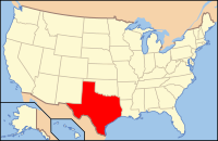
Map of the United States highlighting Texas
Texas's location in the U.S.
Founded 1891
Seat Dalhart
Largest city Dalhart
Area
 • Total 1,505 sq mi (3,898 km2)
 • Land 1,503 sq mi (3,893 km2)
 • Water 2.0 sq mi (5 km2), 0.1%
Population
 • (2015) 7,121
 • Density 4.5/sq mi (2/km²)
Time zone Central: UTC-6/-5
Website www.dallam.org
Footnotes: For infobox source see[1]

County Well Data

Well ID Operator Name Well Type Lease
42-111-00055 DIAMOND SHAMROCK EXPLORATION CO. Gas
42-111-00135 NEWTON CORP.,THE Gas 022272
42-111-30096 Hadson Ohio Oil Company
42-111-30097 Pennzoil Company
42-111-30098 North Central Oil Corp. Gas
42-111-30099 Apache Corporation
42-111-30100 Pennzoil Company
42-111-30101 RED CAVE JOINT VENTURE
42-111-30102 THOMPSON, RICHARD W. INC.
42-111-30103 ESTACADO ENERGY, INC. Oil 06922
42-111-30104 ARCH PETROLEUM INC.
42-111-30105 ARCH PETROLEUM INC.
42-111-30106 ROSEWOOD RESOURCES, INC.
42-111-30107 SAMSON LONE STAR, LLC
42-111-30108 HUNTINGTON ENERGY, L.L.C.
42-111-30109 HUNTINGTON ENERGY, L.L.C. Oil 08035
42-111-30110 CAMBRIDGE PRODUCTION, INC.
42-111-30111 HUNTINGTON ENERGY, L.L.C.
42-111-30112 HUNTINGTON ENERGY, L.L.C. Gas 270474
42-111-30113 H & L EXPLORATION COMPANY, LLC Oil 09471
42-111-80000 Gulf Oil Corp. Gas
42-111-80001 Gulf Oil Corp. Gas
42-111-80002 HEADCO PRODUCTION COMPANY Gas
42-111-80003 Humble Oil & Refining Co. Gas
42-111-80004 DAVIS, TRAVIS H. Gas
42-111-80005 Humble Oil & Refining Co. Gas
42-111-80006 Kerr-McGee Corporation Gas
42-111-80007 DIAMOND CHEMICALS COMPANY Gas
42-111-80008 DIAMOND CHEMICALS COMPANY Gas
42-111-80009 DIAMOND CHEMICALS COMPANY Gas
42-111-80010
42-111-80011 DIAMOND CHEMICALS COMPANY Gas
42-111-80012 ESTACADO ENERGY, INC. Gas 022269
42-111-80013 DIAMOND CHEMICALS COMPANY Gas
42-111-80014 TENNECO OIL CO. Gas
42-111-80015
42-111-80016 UNDERWOOD, RIP C. Gas
42-111-80017 UNDERWOOD, RIP C. Gas
42-111-80018 UNDERWOOD, RIP C. Gas
42-111-80019 UNDERWOOD, RIP C. Gas

For data sources see[2]

References

  1. "Dallam County, Texas". Wikipedia. Retrieved 2020-12-09. 
  2. "RRC Digital Map Data". Railrod Commission of Texas. 2020-10-15. Retrieved 2020-10-15.