Iron County, Utah
| Iron County, Utah | |
|---|---|
|
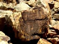
The Parowan Gap petroglyphs, a well-known landmark in Iron County, July 2007 | |
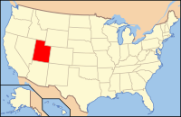
 Location in the state of Utah | |
 Utah's location in the U.S. | |
| Founded |
January 31, 1850 (created) January 17, 1851 (organized) |
| Named for | Iron mines |
| Seat | Parowan |
| Largest city | Cedar City |
| Area | |
| • Total | 3,301 sq mi (8,550 km2) |
| • Land | 3,297 sq mi (8,539 km2) |
| • Water | 4.4 sq mi (11 km2), 0.1 |
| Time zone | Mountain: UTC-7/-6 |
| Website | www.ironcounty.net |
| Footnotes: For infobox source see[1] | |
Contents
County Well Data
| Well ID | Operator Name | Well Type | Well Status |
|---|---|---|---|
| 43-021-30007 | PIERCE, ANDY | OIL & NATURAL GAS WELL | WELL DEVELOPMENT |
| 43-021-30008 | DELTA PETROLEUM CORP | OIL & NATURAL GAS WELL | WELL DEVELOPMENT |
| 43-021-30010 | CEDAR MOUNTAIN GAS, LLC | OIL & NATURAL GAS WELL | WELL DEVELOPMENT |
For data sources see[2]
References
- ↑ "Iron County, Utah". Wikipedia. Retrieved 2020-11-04.
- ↑ "Oil and Natural Gas Wells". Homeland Infrastructure Foundation-Level Data. 2019-09-24. Retrieved 2020-09-12.
