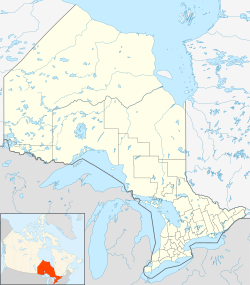
Walpole Island 46, Lambton, Ontario
| Walpole Island 46 Bkejwanong | |
|---|---|
| Unceded territory | |
| Walpole Island Indian Reserve No. 46 | |
| Country | Canada |
| Province | Ontario |
| County | Lambton |
| First Nation | Walpole Island |
| Area | |
| • Land | 137.47 km2 (53.08 sq mi) |
| Population (2006) | |
| • Total | 1,878 |
| • Density | 13.66/km2 (35.4/sq mi) |
| Time zone | EST (UTC-5) |
| • Summer (DST) | EDT (UTC-4) |
| Area code(s) | 519 and 226 |
| For infobox source see[1] | |
Contents
Subdivision Well Data
| Well ID | Operator Name | Spud Date | Well Status |
|---|---|---|---|
| T001469 | Home Oil Company Limited | 1963-08-31 | Abandoned Well |
| T001587 | Texaco Exploration Co. | 1964-12-17 | Unknown |
| T003071 | 79902 Resources Limited | 1970-07-30 | Abandoned Well |
| T003325 | 79902 Resources Limited | 1972-01-25 | Abandoned Well |
| T003326 | 79902 Resources Limited | 1972-01-19 | Abandoned Well |
For data sources see[2]
References
- ↑ "Walpole Island First Nation". Wikipedia. Retrieved 2020-09-15.
- ↑ "OGSR Library - Wells". Oil, Gas & Salt Resources Library. 2019-06-13. Retrieved 2020-08-07.
